Latin America is the region with the greatest level of inequality in terms of land concentration in the world: 1% of rural landowners hold 51% of farmland. While the region as a whole already holds a high GINI index of 0.79, South America, however, leads with an index of 0.85, the highest concentration in the entire continent.1 The expansion of the agricultural frontier, induced mainly by the global demand for soybeans and meat, is the main factor aggravating poverty and the unequal access to land in South American countries, mainly in those regions labelled as priority zones for the expansion and investment of the agribusiness.
According to a FAO (Food and Agriculture Organisation of the United Nations) assessment carried out in 2000, around 2.8 billion hectares of arable land were available at the time in the world to expand the agricultural frontier, 80% of it in Sub-Saharan Africa and Latin America, particularly in seven countries: Angola, Congo, Sudan, Argentina, Bolivia, Brazil and Colombia. A review of the 2012 study decreased the extension of the “arable expansion zones” to 1.4 billion hectares by excluding marginal land (of low quality for agriculture), forest protection areas and non-agricultural areas, but including five other potential areas: Mozambique, Tanzania, Zambia, Indonesia and Venezuela. Amid multiple post-2008 crises, the pressure on the control of land and resources of interest, such as water and biodiversity, increased considerably in these “land reserve zones”, either for productive use or as financial assets. On top of this, nature-based climate solutions to overcome the climate crisis, focused on using forests and other ecosystems as the main carbon stocks, end up intensifying even more the dispute over land reserves and real estate speculation around the world.
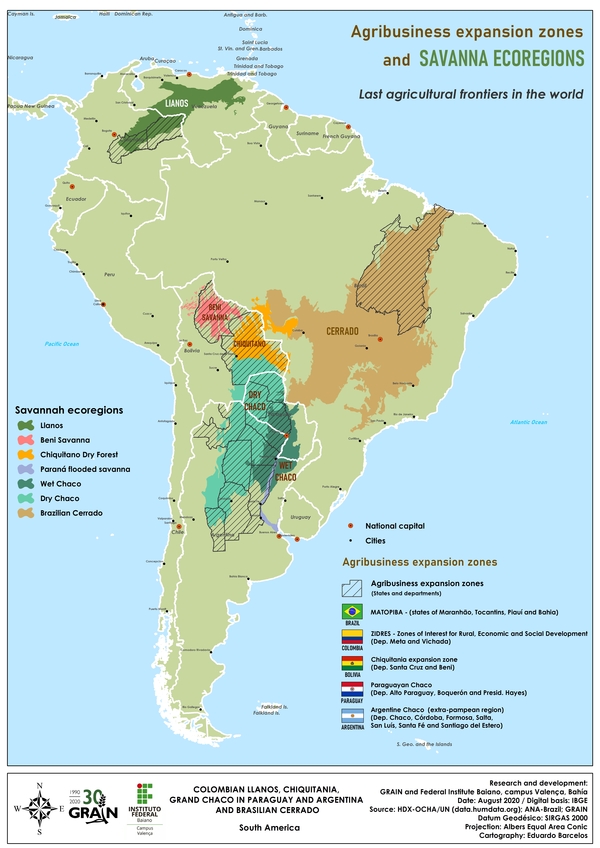
In this report, we assess the land situation in five agribusiness expansion and investment zones in South America: Orinoquia or the Llanos Orientales (Eastern Plains) in Colombia; Matopiba in the Brazilian Cerrado region; and -the regions located along the export corridor of the Paraná-Paraguay waterway- the dry Chiquitan forests of Bolivia, the Chaco Seco of Paraguay and the Argentinian Chaco. In these five expansion zones one can find:
- A high concentration of the best arable land in large properties, usually over two thousand hectares. Even in Bolivia, which imposes limits of up to five thousand hectares per owner, in the expansion zone of Santa Cruz and Beni, areas of up to six thousand hectares have been legalised and titled. In the Orinoquia region in Colombia, the average property reaches 10 thousand hectares, while 36% of the Argentinian surface is controlled by properties ranging from 10 to 20 thousand hectares. North from there, in Paraguay, 40% of the land is encased in 600 properties that are over 10 thousand hectares each. In the Brazilian Cerrado, one can now find estatesof over one million hectares with soy production;
- The prevailing use of these lands for soybean monocultures or livestock pastures destined for export, as well as a significant increase in the destructionof native vegetation resulting from the accelerated conversion of land use by the advance of the agricultural frontier. Of the 16.5 million hectares converted to agricultural use in Brazil in the last 10 years, 12 million of these were set apart for soybeans. Bolivia’s deforestation record stands out (five million hectares in 2019 alone), while 80% of the Argentinian Chaco was converted into land for pasture and agricultural production;
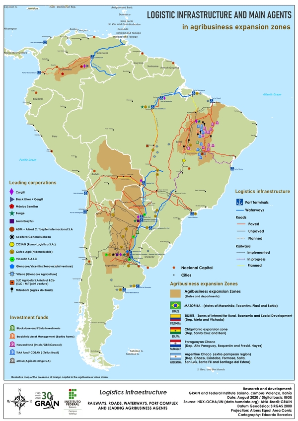
- The increased foreign control of land as well as of export-oriented logistical infrastructure, mainly by the export sector’s trading companies. The control of strategic port terminals by Cargill and COFCO in all these expansion zones, as well as the intense acquisition of Matopiba lands by pension and investment funds, are clear examples. The foreign takeover of the control of land is especially relevant in Paraguay, as it is estimated that 35% of its lands are under direct or indirect foreign control, whereas in the expansion zone of Santa Cruz de la Sierra, in Bolivia, 60% of its most productive lands are under the control of international corporations;
- Ongoing processes ofthe digitisation of land governance to resolve property rights through cadastre registration with land georeferencing have neglected collective territories in all the countries analysed, thus laying the groundwork to the handover of land to the land market;
- Massive individual titling of private properties and the suspension of collective titling and agrarian reform processes, including in Bolivia, ranked first in Latin America for its protection of collective territorial rights. In the Santa Cruz region, 1.8 million hectares of the best lands were excluded from land reform by the land cadastre and later titled to agricultural corporations;
- Specific laws and policies for attracting capital market investments in land, in logistics infrastructure and in agribusiness value chains, secured by rural assets created specifically as debt guarantee, such as land (or parcels of it), the future harvest or even “environmental services”. Clear examples of this are Colombia’s zones of interest for rural, economic and social development (ZIDRES), which are privileged beneficiaries of land and credit policies, as well as the transformation of agribusiness bonds in Brazil into movable assets, including those issued in foreign currency and managed by the financial market with tax exemptions in their transactions.
In all the countries studied, the georeferenced cadastres became a requirement both for the land regularisation process and to access other public and credit policies in the financial system for rural properties. This trend to digitise land governance and the natural resources linked to it, is being reinforced by the World Bank: it has allocated USD 45.5 million for the registration of the Brazilian Cerrado’s private rural properties in the rural environmental cadastre (CAR) and has also assigned USD 100 million to the multi-purpose cadastre in Colombia.
[ An in-depth analysis of the five countries covered by this report is available in Spanish and Portuguese here]
 Click on map to zoom in
Although the improvements in localisation technology and the measurement of property limits – called land governance digitisation – can contribute to the process of titling/identification of public, vacant, collective/community and private lands in order to claim back properties under illegal status, the enrollment in the cadastre by each landholder without being verified by the state, ends up validating the historic process of land grabs. In the five main areas of expansion in South America covered by this report, there is widespread individual titling in favour of those who first access digital precision systems (GPS), on public, vacant lands and on lands traditionally occupied by traditional peoples and communities. This is authentic digital land grabbing.
Even in Argentina and Paraguay, where these cadastres must be integrated with the information contained in real estate registries before deciding on property rights to land, the focus on the title and on the accuracy of the GPS measurement has been replacing the verification criteria related to the compliance with the social and environmental function of the land and to the nature of the occupation. Therefore, in the current trend, cadastres are being used as a new backing for property rights, validating wrongful titles derived from grabbing public lands and the territories of traditional peoples and communities. This is the case of Paraguay’s SIRT cadastre and the tierras mal habidas (lands illegally obtained), as well as Bolivia’s CAT-SAN, which gave registration priority of the best arable lands on dispute in Santa Cruz de la Sierra to agricultural corporations. Brazil currently allows, by means of a Decree, the regularisation of up to 1,500 hectares of public lands through CAR and on information provided by the applicant.
There is a clear focus on georeferencing in agribusiness expansion zones and almost exclusively over private rural properties, comprising the entirety, or part, of communal lands and agrarian reform settlements under collective land management. Even if communal lands are certified, public institutions and banks have been demanding their registration in the cadastres as private rural properties, which generates the overlap of several individual cadastres with collective lands, or even the deletion of these territories from the map.
 Women from the OMMI organisation, from the community El Estribo. Paraguay. Credit: Nicolás Avellaneda – Plurales Foundation
This pressure to register them in the cadastre as private property occurs because public lands, collective/communal territories and agrarian reform settlements are inalienable and can not be used as debt guarantees, thus, hindering the way of the real estate and securities markets for financial investments based on rural assets on private property.
With this digital redesign of land use -focused on individual private property- and the land regularisation that has followed -based on individual titles to consolidate property rights, millions of hectares are being injected in the land market, in global value chains (including in “sustainable” ones) and in the stock market, since it is now possible to sell and use them in relation to debt.
It is from these virtual territories legalised by the cadastres that the main agents that operate the agribusiness value chain promote the idea of sustainable global chains, whose production would be deforestation-free. Once the crimes of the invasion of public lands and deforestation (as in the case of the CAR in Brazil) have been erased, from the moment they’re registered in the cadastres, the origin of the products in the value chain -mainly soya and meat- is re-issued, and are then validated as «sustainable» by the verification and traceability systems of the new technological infrastructure of these long chains, typical for commodities (Blockchain technology). But this doesn’t stop there. Out of sight from the map, out of mind from the world and the same satellite images that guarantee the land and the environmental compliance of private properties become systems of surveillance and criminalisation against peoples and communities that have been “erased” from their own territories, whose way of life has become a crime against property.
In addition to the “green” re-issue of the real estate market and the commodities chain, the issue of new financial securities on rural assets – such as land ownership and environmental services (green bonds) – is allowed. Its purpose: to provide a buffer for liquidity in the capital market and to leverage financing for production and infrastructure in the agribusiness value chain. Properties holding titles and georeferenced in the CAR and/or SIGEF (Land Management System) cadastres in Brazil, for example, represent the new guarantee for issuing financial securities on land and natural resources, such as the Environmental Reserve Quota (Cota de Reserva Ambiental – CRA) on one hectare of native vegetation or the agribusiness bonds, that have the land, the future harvest or environmental services as debt guarantee for loans obtained from investors, mainly foreigners. This way, the digitization of land governance and of its natural resources by linking georeferenced cadastre and the real estate registry becomes the new guarantee, as well as the means for the quick delivery of business transactions from land in this digital phase of the financial economy. An unprecedented concentration of land, natural resources and the agro-food system is underway, no longer by the agribusiness sector, but by a few actors from the financial market, further deepening the scarcity inherent to the corporate agrifood system.
It is not just a digital makeover of the surface that is underway, but a recomposition via images «with technological precision» of the history of landscapes, territories, agrobiodiversity and their peoples. As a rule, the territories of the «erased» peoples, identified as demographic «voids» or private properties, are precisely in the priority areas of agribusiness expansion and investment. These are contemporary arenas not only of land disputes, but of the right to exist, the right to other ways of life, other types of development and future possibilities outside the realm of private property and the financial market.
 Click on map to zoom
BRAZIL – MATOPIBA
In 2000, the FAO identified the Cerrado region as the world’s most important agricultural expansion zone. In the following decade, MATOPIBA was defined by the United States Department of Agriculture (USDA) as “Brazil’s latest agricultural frontier”. Currently, the Cerrado region accounts for approximately 45% of the national agricultural area, responsible for 52% of the country’s soybean production with much of its land and logistics infrastructure handled by foreign agroindustrial conglomerates, like the agro ABCD, the Chinese Cofco Agri, but even by actors that are not part of the sector, like Brookfield Asset Management, Cresud Mitsui, Mitsubishi, Valiance Capital, Private Equity Patria Investimentos/Blackstone and other foreign investment funds such as the Teachers Insurance and Annuity Association of America – TIAA and Harvard Endowment.
An unimagined financialisation of land, natural resources and the agro-food system is underway in Brazil, mainly through a credit system financed by the capital market and no longer controlled by the State, which demands an ever-increasing release of land as private property, the main guarantee for financing, and a debureaucratisation of land regularisation processes to speed up land titling. Land digitisation is crucial for this.
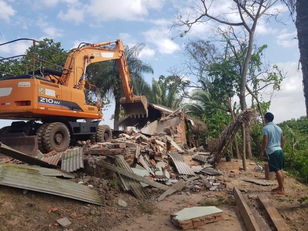 The Cajueiro (MA) community in Brazil struggling for the right to exist has its houses destroyed for the construction of the private port in the region by the WTorre construction company, in association with China Communications Construction Company (CCCC) Photo : Vias de Fato @Media Ninja
The deletion of collective territories and the digital redesign of land as private property through the Rural Environmental Cadastre (CAR) is evident: as of March 2019, only 6% of the territory available for cadastration (34.5 million hectares) in the CAR information system (SICAR) was acknowledged as indigenous land, quilombola territories and territories of traditional peoples and communities, although official data indicates that indigenous territories solely account for 117 million hectares or 13.7% of the national territory.19 However, although official government databases point out that about 43% of the country’s territory consists of private areas, 91% of it was declared private rural property in the land cadastre of the national rural registration system (SNCR), an increase of one third from 2016 to 2018, following the approval of the so-called “Land Grab Act”. 21
COLOMBIA – ORINOQUÍA
In 2016 Colombia created the zones of interest for rural, economic and social development (ZIDRES: Zonas de Interés de Desarrollo Rural, Económico y Social) so that public and vacant lands of any size could be granted by contract/concession and for an unspecified span of time to the agroindustry, breaking with what had been the norm until then, of privileging the allocation of public lands to the most vulnerable categories of people from the countryside, indigenous peoples, Afro-descendants and victims of the armed conflict. In addition to the subsidised land concession, economic operations based in the ZIDRES are the main recipients of development and funding benefits with privileged credit lines.23
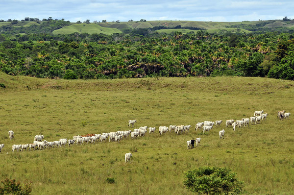 Cattle in the «llanos». Credit: ©2011CIAT/NeilPalmer @Flickr
Of the approximately 7.2 million hectares (6.2% of the territory) authorised to be used as ZIDRES, 5.5 million hectares are in the Llanos Orientales or Orinochia (76.3%), of which 4.8 million are in Vichada (66%) and 2.3 million in Meta (32%), the main departments of the ecorregion.24 This has resulted in the establishment of an authentic market of public lands – of the baldíos de la Nación – in the region. The irregular accumulation of baldíos (wastelands) is especially intense in Orinochia, mainly in the region of Altillanura, considered the last agricultural frontier of Colombia and the place with the highest land concentration in the country, with properties extending on average beyond 10 thousand hectares.25
The registration of these extensive wastelands as private properties in the multipurpose cadastre – the electronic land information and georeferencing system in Colombia – lays the groundwork for the consolidation of private property over public lands and their insertion in the land market. Although the cadastre does not require property registration records and, therefore, cannot justify the issuance of titles that confer the right to own land, the World Bank is committed to the integration of cadastre and land registration systems, with funding of USD 100 million, through the IBRD, having as goal the digitisation of 100% of the country’s territory through the issuance of 67 thousand titles covering 1.5 million hectares by 2025.26
ARGENTINA – CHACO
Argentina has also been integrating territorial information based on geospatial precision technology, but unlike Brazil and Colombia, the spatial cadastre is already connected to the real estate registration system that issues property rights titles. Although the information contained in the cadastre and in the property’s registration documents must match, there is no general rule as to how to verify the origin of the title, the nature of the possession or the fulfillment of the social function of the land before validating the titles. Each province is allowed to define its own procedure for land regularisation and issuance of the cadastral certificate. This document constitutes, modifies or transfers property rights in the country.27 The national program of rural titling (ProntAR) also allows private property regularisation over public lands in favour of cooperatives and agricultural consortia that demonstrate peaceful and uninterrupted possession.
 Argentina, Gran Chaco, Salta; Wichi girl herding goats. Credit : WestEnd61
Whereas those who do not have access to georeferencing technology are not entitled to a cadastral certificate and the title, the integration of geospatial information without proper analysis of the registration documents and of the nature of possession may end up endorsing the historic land grab of public lands, especially in favour of foreigners, given the deregulation of the limits to land access by foreigners that has been implemented since 2016 by the Macri government.28 Until 2017, 40,216.5 hectares received land titles and benefited 1,040 farmers (usually related to livestock production). In its report the government doesn’t clarify, though, whether those benefiting were small, medium or large farmers, individuals or legal entities, nationals or foreigners.29
Property titling is fundamental to the process of financing the rural credit system in Argentina, which has been mainly leveraged since the 2000s by the creation of trusts (fideicomissum) through investment funds. These then hold land as a guarantee, as well as by the issuance of securities on production, such as warrants, issued even in dollars and only to foreign actors.30 31 Between 2004 and 2008, the creation of temporary trust in the rural sector increased by 271%, and according to the 2018 Census, 208 trusts (fideicomissum) held 235 thousand hectares in the country. 3233
The expansion across Latin America of Argentinian mega-companies like Los Grobo was driven by the creation of trusts (fideicomissum). In turn, warrants with financial guarantees accounted for 87% of the certificates issued in 2018, representing around USD 806 million.
PARAGUAY – CHACO
Government incentives have been continuously promoting plots of land at bargain prices in the Paraguayan Chaco, either through credit policies or by the subsidised regularisation of the illegal land grab of public lands. Of the 7.8 million hectares of public land or those bought with the use of public budget from 1954 to 2003 and granted illegally in the country (the so-called tierras mal habidas), 80% are located in the Chaco region.34 On average, 4,600 hectares were allocated per person, mainly to politicians, local elites and military personnel.35
In 2014, with the support of the United Nations Development Programme (UNDP), the Land Resources Information System (LRIS) was created to identify the geographic and registration situation of the fiscal lands granted by the state and to update the situation of the 1,011 peasant colonies of the eastern region through the institute for rural and land development (INDERT) in order to initiate the procedures for the return of «wrongly held» lands (tierras mal habidas), according to article 47 of the Agrarian Statute. Although INDERT should verify the origin of the title, the type of occupation and the socio-environmental function of the land, as well as if the holder meets the criteria of an agrarian reform beneficiary to validate the registration at the georeferenced cadastre, INDERT considers legitimate those titles that have already been paid for, even irregular ones that have simply been registered on the SIRT cadastre.36
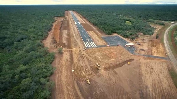 Construction of a new paved landing strip at the Infante Rivarola airfield , with access from the Transchaco Route. Credit : MOPC – Ministry of Public Works and Communications of Paraguay
The enrollment in the cadastre has served to cover up and legitimise wrongful titles and illegal possessions in the settlements, orchestrating an authentic digital land grab of the tierras mal habidas.37 Once dully titled and recognised, the lands “legally” obtained by this digital makeover are injected into the land market and end up backing up rural assets as debt guarantees in favour of foreign investors, the same that have historically dominated the agribusiness value chain in Paraguay.38 Backed by rural assets, it is through the capital market that financialised agribusinesses intend to transform the Chaco region into a zone of development and investment. To that end, investors envision turning the region into an international transport hub, which would triple to around USD 5 billion the annual value of the commodities transported through the Transchaco highway (Route number 9), the main export corridor for the region’s production to the port terminals in the Paraguay-Parana waterway.39
BOLIVIA – CHIQUITINIA (SANTA CRUZ AND BENI)
Although rough figures point to a greater land extension set apart for indigenous peoples and/or collective and community titles, about 70% of the best arable lands in the country are reserved and titled in favour of agribusiness companies, particularly international ones, located in the Chiquitania region.40 41
During the process of land redistribution and titling in Bolivia (saneamiento de las tierras), priority zones were identified. This was in the framework of the national land management project, financed by the World Bank (1992-1995) and associated with another project of the bank called Proyecto de Tierras Bajas del Este.42 43 These zones were meant to guarantee the right to property over those lands with the best agricultural potential in the country. The goal: to build an economic framework for the commercial production of soybeans for export. These priority zones were composed of areas under dispute in terms of possession and ownership, which were, therefore, supposed to carry out the Integrated Land Use Cadastre ( Saneamiento Integrado al Catastro, CAT-SAN), a modality that combines the registration of the property in public registries with the enrollment in a legal cadastre containing georeferenced information about the property, offering priority on property rights in the event of overlapping titles over the same area. Of the 2.5 million hectares identified as priority zones, 1.8 million are in Santa Cruz de la Sierra, according to the company INYPSA hired by the World Bank.44 45
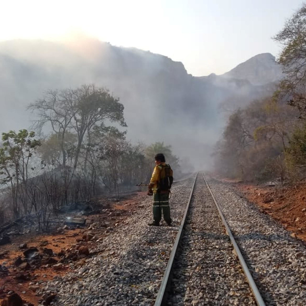
Area affected by forest fires that destroyed hectares of forest in Robore, Bolivia, August 19, 2019. Credit : Santa Cruz Department via REUTERS
As a result of this program, there was an increase in titles given to medium-sized properties and agricultural companies, especially foreign ones. It is estimated that transnational companies like ADM, Cargill and Bunge, as well as financial actors such as the Venezuelan investment group Gravetal, control directly or indirectly (contract farming) about 60% of the most productive lands in Santa Cruz de la Sierra. 46 47 48
The individual titling of properties was essential to introduce arable land in the land market, considering that the Community Land of Origin (tierras comunitarias de origen – TCOs) and community properties cannot be commercialised; they cannot be sold or given as guarantee. Individual titling of properties was also essential if access to land was to be given to foreign companies, as the sale or assignment of public land to foreigners in Bolivia is prohibited. The individual private digitisation and titling program of fiscal lands (whether small, medium or large) was the first step towards facilitating the handover of land to foreign capital, either through sale or contract, and therefore establishing the special agribusiness investment zone in Chiquitania.
RESISTANCE OF TERRITORIES:
– Comprehensive land reform and collective territories against the commodification and financialisation of land, natural resources and the agro-food system. Collective territories, agrarian reform settlements (for a fixed period, usually over 10 years) and public lands are lands out of the real estate market, such as commodities, and the securities market, as assets in the financial market. As they cannot be sold, leased (with exceptions) or offered for debt enforcement by financial institutions, they are territories of resistance to the process of commodification and financialisation of land, resources and the food system.
– Access to land is not land regularisation. A constitutional and legal provision exists in all countries where these areas of agribusiness expansion exist, that allows the priority allocation of public lands to the collective territories of indigenous peoples and traditional communities, as well as to the beneficiaries of agrarian reform settlements.Before creating any land regularisation program based on the issuance of individual property titles, it is the obligation of states and multilateral funding agencies such as the World Bank to allocate public and private lands recovered due to irregularities to indigenous peoples, Afro-descendant communities, traditional communities and to those benefiting from agrarian reform.
– Land governance digitisation cannot generate property rights. Geo-referenced cadastres cannot be legal criterion to support the legality of titles registered in public registry offices or of land tenure. Otherwise, the process of land digitalisation risks turning into a real redesign of the surface focused on private property, opening the gates to a massive digital land grab.
– Prior to cadastres and titling, we must build binding systems of verification and constantly monitor the fulfilment of the social and environmental function of the land. The verification and monitoring of the compliance with the social and environmental function of the land, of the origin of the possession (non-violent) and of the validity of the titles registered based on the survey of the history of the chain of title, are that which allow public or private property, individual or collective, to be protected in any State, whether liberal or social.
– Digital land cadastres cannot be a requirement to access public policies and rural credit, at the risk of excluding from land those who do not have access to it, cannot pay for georeferencing or even register as a collective territory. The massive investment by the World Bank to enroll land in these cadastres as private property – whether small, medium or large – has contributed to the deletion of collective territories and their insertion in the land market.
– Private ownership of land does not mean ownership of the natural resources, called “environmental services”. Forests, native vegetation, water, biodiversity and their environmental functions are not part of the rural patrimony of the owner. In all Western democratic constitutions the environment makes up the core of human rights in regards to human dignity. This means that it is a non pecuniary asset, neither public nor private, protected by the legal regime of community property that cannot be appropriated (not even by state entities) and sold on the market like any other commodity. These environmental elements belong to no one. They are destined to all the present and future generations, especially to the traditional peoples and communities that protect them and have used them as a source of survival for thousands of years. The appropriation of these resources by the land owner or by financial titles excludes all, including future generations, from the equitable access to the means that enable life to grow, threatening life itself on the planet.
– Financialisation creates scarcity. The issuing of financial assets or securities on land ownership (or on parcels of land) and on community assets that do not comprise rural assets, such as environmental services (native vegetation, water and biodiversity) must be prohibited. The transformation of land as a value into shares aims to give liquidity to the financial market, placing land (or fractions of it) and its resources, such as crops and so-called «environmental services», in the hands of a few financial agents, who go on to control and speculate on land prices, carbon and biodiversity markets and on agricultural commodities, endangering the entire food system.
Furthermore, the commitment to leverage financing for environmental management through the financial market by issuing environmental assets (green bonds) leads to an even greater scarcity of environmental goods to be protected. Within the logic of supply and demand and the typical speculations of financial assets, the scarcer a commodity is, the higher its market value will be. In an extractive economy that causes scarcity of forests and native vegetation, through high rates of deforestation, scarcity of clean air, climate deregulation, and with increasing emissions of greenhouse gases, the green assets that these scarce natural resources represent will be increasingly valued in financial market. The higher the profit of the extractive economy of agribusiness and oil, the higher the profit of the financialised green economy, thus rendering it ineffective for the management of the environment. The appropriation and financialisation of land and natural resources are mechanisms that induce greater scarcity.
The collective stewardship of biodiverse lands by the world’s indigenous peoples, traditional and peasant communities for nearly 12,000 years is what has preserved the environment and the supply of food and nutritional diversity for all of humanity. Therefore, the real alternatives lie in keeping the essentials outside the realm of property and markets.
This report contains:
- Map of Expansion Zones and Savannah Ecoregions
- Map of logistics infrastructure in the expansion zones
- Map of Corporations and Investment Funds in the Expansion Zones
- Map of logistics infrastructure and agribusiness actors in areas of expansion
- Table detailing the map features
*******
Acknowledgments: Junior Aleixo, PhD researcher at the Postgraduate Program of Social Sciences in Development, Agriculture and Society (CPDA/GEMAP/UFFRJ), who collaborated with data and the review of the report; Eduardo Barcelos, professor at the Instituto Federal Baiano (IFBAIANO), responsible for the cartography/maps in the report.
__________________________
Source and Image: https://grain.org/en/article/6529-digital-fences-the-financial-enclosure-of-farmlands-in-south-america
 Click on map to zoom in
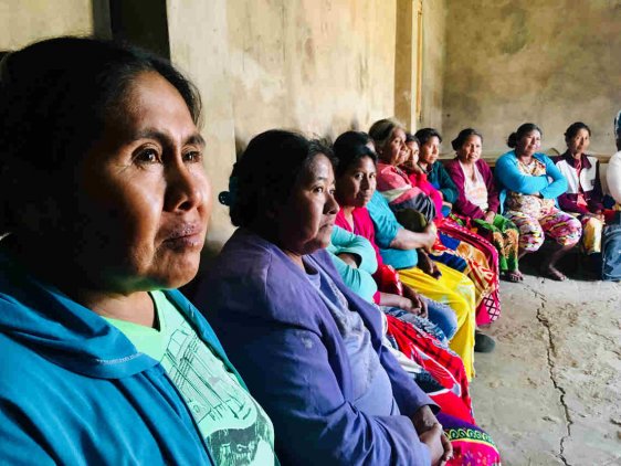 Women from the OMMI organisation, from the community El Estribo. Paraguay. Credit: Nicolás Avellaneda – Plurales Foundation
 Click on map to zoom
 The Cajueiro (MA) community in Brazil struggling for the right to exist has its houses destroyed for the construction of the private port in the region by the WTorre construction company, in association with China Communications Construction Company (CCCC) Photo : Vias de Fato @Media Ninja
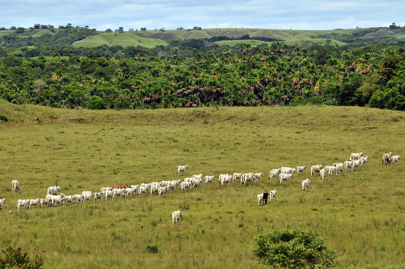 Cattle in the «llanos». Credit: ©2011CIAT/NeilPalmer @Flickr
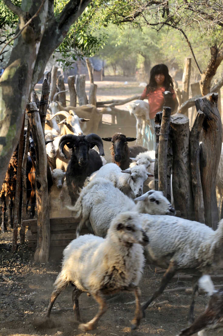 Argentina, Gran Chaco, Salta; Wichi girl herding goats. Credit : WestEnd61
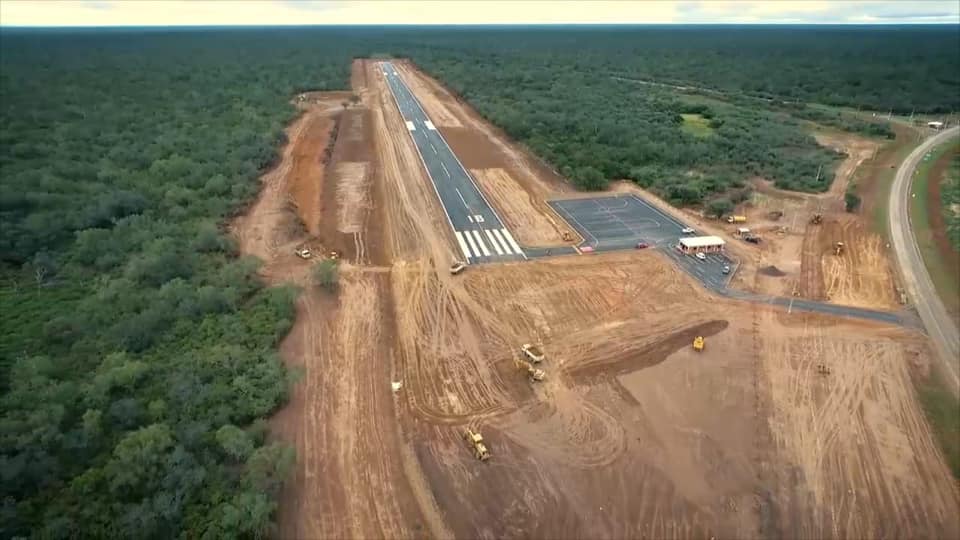 Construction of a new paved landing strip at the Infante Rivarola airfield , with access from the Transchaco Route. Credit : MOPC – Ministry of Public Works and Communications of Paraguay


 Users Today : 10
 Total Users : 35459476
 Views Today : 13
 Total views : 3417771