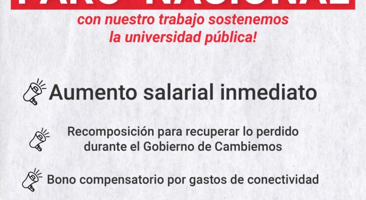
Ante la falta de respuestas del Gobierno Nacional a nuestras urgentes demandas lxs docentes de todas las universidades nacionales hacemos un *paro total de 48hs.* la semana que viene.
Tras el derrumbe del poder adquisitivo de nuestros salarios durante el Gobierno de Cambiemos, este año venimos perdiendo mes a mes contra la inflación. El Gobierno no respetó el último punto de la paritaria 2019 (que establecía una cláusula gatillo para el mes de febrero de este año) y se comprometió a una instancia de negociación para julio que lleva tres meses sin cumplir.
Este *miércoles y jueves* lxs docentes paramos por todas nuestras reivindicaciones:
▶️ Aumento salarial inmediato por encima de la inflación acumulada en 2020
▶️ Plan de recomposición para recuperar el valor del poder adquisitivo del salario a los niveles de 2015.
▶️Bono compensatorio por los gastos realizados en el teletrabajo (herramientas tecnológicas, conectividad, etc.).
▶️ Partida presupuestaria extra para garantizar los reemplazos.
El ministro de Educación defiende que se «vista de forma republicana» y dos ministras de Macron le acusan de coartar la libertad de las mujeres.
Un cartel en un instituto de Borda, al suroeste de Francia, bajo el título: «Vestimenta correcta exigida», ha desatado la polémica en todo el país. En la imagen, la parte de arriba del cuerpo de una chica con un top tachado y al lado, las piernas de otro cuerpo femenino con una minifalda, tachado también.
La dirección del colegio advertía de esta forma que estaba prohibido que las chicas fueran a clase con minifaldas o tops. La reacción de las jóvenes del instituto (y de gran parte del país) no se hizo esperar. El pasado 14 de septiembre, convocadas a través de las redes sociales (con el hashtag #14september), acudieron a su instituto «con la ropa más provocativa» que encontraron. Un desafío a la moral establecida pero también al propio ministro de Educación galo, Jean-Michel Blanquer, que se ha colocado en el centro del huracán con sus últimas declaraciones el pasado lunes.
«Todo el mundo puede entender que uno tiene que ir al colegio vestido a la manera republicana, es decir, una vestimenta que permita una mayor igualdad entre todos y no diferenciarse por la ropa». ¿Qué es vestirse de manera republicana? «Basta con vestirse de manera normal y todo estará bien», aseguró en una entrevista en la RTL.
Y no era la única apreciación de Blanquer que han caído como una bomba: «[La medida] tiene un sentido de protección». «La escuela no es un lugar como cualquier otro». «Una cierta sobriedad en la vestimenta es una apuesta por la igualdad que protege a los niños y las niñas». «No vas al colegio como si fueras a la playa o a la discoteca«.
Sus afirmaciones han dividido al Gobierno, con dos ministras enfrentándolo, y han levantado en armas a la mayoría de las adolescentes que aseguran que el cartel y la prohibición es una forma directa de coartar la libertad de la persona para vestir como quiera: «Es decir a las mujeres que se cubran, que no se pongan ropa demasiado corta. Seguramente nos dirán que distrae a los chicos, que es explícito. Para que los hombres puedan vestirse como quieran. Nos sexualizan ¿Deberíamos usar un suéter para complacerlos? ¿Deberíamos usar 3 capas de ropa para que no moleste a sus frágiles ojos? Es inadmisible», se leía en el post de Instagram en el que una de las estudiantes del instituto denunció la situación y que se ha hecho viral.
La primera ministra en pronunciarse fue la delegada de Ciudadanía, Marlène Schiappa, quien utilizó Twitter para animar al movimiento 14septiembre a reivindicar su libertad de usar faldas, escotes, maquillaje… «Hoy #Lunes14septiembre, jóvenes de toda Francia han decidido espontáneamente llevar faldas, escote, crop-top o maquillaje para afirmar su libertad frente a los juicios y actos sexistas. Como madre, las apoyo con sororidad y admiración«, aseguró.
La segunda ha sido la ministra de Igualdad, Elisabeth Moreno, quien ha dejado claro en una entrevista en Le Parisien que «en Francia, cada uno es libre de vestirse como quiera. Las mujeres tardaron siglos en liberarse de los códigos de vestimenta. Esta libertad duramente ganada no tiene precio«.
En España
Nuestro país no es ajeno a esta polémica ya que hace dos años, en un instituto de Torrevieja, se vivió una situación parecida cuando el centro prohibió a las alumnas ir con pantalones cortos a clase (en septiembre, en el sur de Alicante y con casi 40 grados). Las chicas se rebelaron, los padres las apoyaron pero ningún responsable educativo entró en la polémica.
«Es muy difícil marcar qué es estar bien en el contexto de aula. ¿Quién lo marca? Yo educaría la mirada, porque la mirada sobre el cuerpo de la mujer es siempre sexual. Una mujer con un top o con un escote inmediatamente se convierte en un objeto de mirada sexual. Y eso es lo que hay que educar: una masculinidad en la que el cuerpo de la mujer sea tan absolutamente natural como el cuerpo del hombre y además esté libre de prejuicios sexualizados. Si no, lo que conseguimos es sexualizar a niñas muy pequeñas«, advierte Marian Moreno, experta en coeducación.
Moreno denuncia que este tipo de normativas siempre caen sobre la mujer: «Siempre somos nosotras las que estamos bajo la mirada de la sociedad. Siempre es nuestro cuerpo el que va por delante. En los institutos nunca se le ha dicho a ellos, con una normativa, que no pueden enseñar el calzoncillo, no se considera falta de decoro… Ahora un top o una minifalda, sí. ¿De verdad la sociedad no está preparada para la libertad de las personas en este sentido?«, denuncia.
El problema, según esta experta, no es tanto que se hable el tema sino cómo se habla: «Tratarlo como una forma de prohibición, nunca educa, y menos en la adolescencia donde no sólamente es una explosión hormonal sino de rebeldía frente al mundo adulto. Están buscando su sitio y si el mundo adulto les dice ‘esto está prohibido’, lo que hace es limitar».
¿La solución? «Un buen programa de coeducación donde no haya ninguna diferencia entre chicos y chicas en lo que significa estar bien en un espacio«. Y ahí las autoridades tienen que jugar un papel clave: «¿Las autoridades educativas tienen una mirada de igualdad entre chicos y chicas? Tendrían que tener formación en género para que no se produjeran situaciones como estas en las que se produce un desequilibrio absoluto dependiendo de si eres chico o chica. Este ministro ha mirado el tema desde una masculinidad que sexualiza el cuerpo de la mujer«.
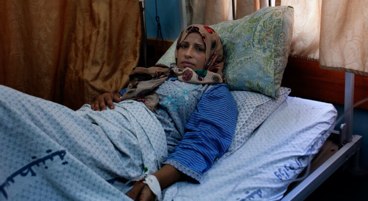
Marta, una niña indígena guatemalteca, celebró el pasado lunes sus 15 años con una pequeña fiesta en su hogar. Sin embargo, casi no sonríe y la vida no es la misma desde 2018 cuando fue abusada sexualmente por un maestro del sistema público. En idéntica situación se encuentran otras 22 estudiantes con denuncias similares en el departamento de Alta Verapaz, al norte del país.
Casos como el de Marta sobran en Guatemala. El delito de violencia contra la mujer es el más cometido del país. Sin embargo, la abogada feminista Lilian Vásquez se resiste a normalizar la situación y desde 2014 apoya a quien lo necesita por violencia de género. En este caso, se enteró de la situación meses después de lo ocurrido.
Cerca de dos millones de bebés nacen muertos cada año, la gran mayoría -un 84%- en países de ingresos bajos y medianos bajos. Si la COVID-19 reduce los servicios de salud a la mitad podría causar casi 200.000 casos adicionales en 117 países, destaca un informe de la ONU. «Más allá de la pérdida de vidas, los costos psicológicos y financieros para las mujeres, las familias y las sociedades son graves y duraderos», señala la directora del fondo para la infancia.
El estudio de varios organismos* del sistema de Naciones Unidas, que define a un mortinato como a un bebé que nace sin signos vitales durante la 28ª semana del embarazo o posteriormente, señala que el año pasado tres de cada cuatro de estos casos ocurrieron en África subsahariana o el sur de Asia.
La directora ejecutiva de UNICEF, Henrietta Fore, calificó la pérdida de un niño al nacer o durante el embarazo como una “tragedia devastadora para una familia” y agregó que es una pena que “frecuentemente se soporta en silencio” y cuyo alcance es de ámbito mundial.
“Cada 16 segundos, una madre en algún lugar sufrirá la tragedia indescriptible de parir un mortinato. Más allá de la pérdida de vidas, los costos psicológicos y financieros para las mujeres, las familias y las sociedades son graves y duraderos”, abundó.
Según Fore, esto no debería ocurrir ya que la mayoría de los casos de mortinatos “podría evitarse con un monitoreo de alta calidad, una atención prenatal adecuada y una partera capacitada”.
UNICEF/Rahani Kaur
Una futura madre se prepara para dar a luz en Calcuta (India).
La COVID-19, un riesgo adicional
“Más del 40% de los casos de mortinatos ocurren durante el alumbramiento, una pérdida que podría evitarse si se contara con un trabajador sanitario capacitado durante el parto y en la atención obstétrica de emergencia adecuada. Alrededor de la mitad de los mortinatos en África subsahariana y Asia Central y Meridional se producen durante el trabajo de parto, en comparación con el 6% en Europa, América del Norte, Australia y Nueva Zelanda”, resalta el informe.
Esta situación podría agravarse aún más debido a la COVID-19. Si la pandemia llega a reducir los servicios de salud a la mitad podría causar casi 200.000 casos adicionales de mortinatos durante un período de doce meses en 117 países de ingresos bajos y medianos.
La mortinatalidad no solo sucede en países pobres
En 2019, 39 países de altos ingresos tuvieron un número mayor de mortinatos que de muertes neonatales y en quince naciones esos casos superaron al de muertes infantiles.
El estudio indica que uno de los mayores factores de desigualdad en los países de altos ingresos es el nivel de educación de la madre y que las tasas de mortinatalidad son más altas en las zonas rurales que en las urbanas, en este último caso, sin diferencia en el tipo de nivel de ingreso en el país
“Por ejemplo, en Nepal, las mujeres de castas bajas tuvieron tasas de mortinatalidad entre un 40% y un 60% más altas que las mujeres de castas superiores”.
Del mismo modo, las minorías étnicas de los países de altos ingresos suelen carecer de acceso a una atención sanitaria adecuada. En el informe se observa que las mujeres afroamericanas de Estados Unidos están expuestas a casi el doble de riesgo de mortinatalidad que las mujeres blancas.
* El Fondo de la ONU para la Infancia (UNICEF), la Organización Mundial de la Salud (OMS), el Grupo del Banco Mundial y la División de Población del Departamento de Asuntos Económicos y Sociales de las Naciones Unidas.
¿Qué dicen las estadísticas ante esta terrible disyuntiva?
Entramos en la segunda ola de la pandemia de COVID-19 y tras haber sorteado como se ha podido la primera ola, hemos constatado la factura y fractura económica que ha implicado y, por lo tanto, nos permite pensar acerca del coste que implica parar la actividad económica para esta segunda.
Esto nos ha llevado al debate entre qué debe priorizarse, si la economía o la salud de cara a sobrevivir a lo que se nos viene encima. Se ha estado debatiendo sobre si las medidas de distanciamiento social tomadas por muchos gobiernos pueden generar un perjuicio económico desproporcionado en comparación con el coste en vidas humanas que deviene por la pandemia.
No son pocas las voces tanto políticas como académicas que se han levantado contra las medidas de confinamiento poniendo el acento en que podría ser peor el remedio que la enfermedad. Pero a su vez, también economistas académicos europeos se han mostrado a favor de estas medidas de extrema cautela.
Este terrible dilema entre proteger la salud o la economía entraña un problema ético de gran calado pues ¿podemos establecer un precio a la vida humana? Se han dado ya en la primera ola situaciones en las que, a modo de dilema del tranvía, el personal sanitario se ha visto abocado a tener que priorizar a quien asignar respirador y a quien no.
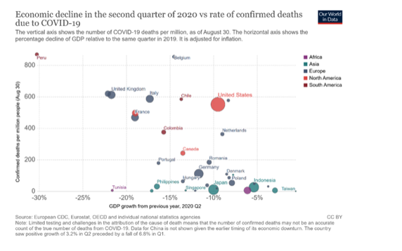
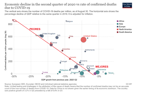
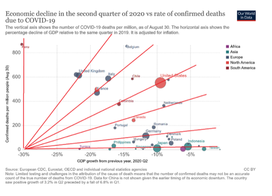
No obstante, si nos atenemos al comportamiento que han demostrado los diferentes países a lo largo del segundo trimestre del 2020, los datos ofrecen una lectura interesante. Our World in Data de la Organización Mundial de la Salud recoge datos en relación con el desempeño de los diferentes países ante la pandemia.
En el gráfico podemos confrontar para cada país el número de muertes confirmadas por Covid-19 por millón de personas frente a su tasa de crecimiento anual del último trimestre.
Sin tomar en cuenta otras posibles variables que pudieran mediar entre la irrupción de la pandemia y el desempeño de cada país, una relación en la que hay que decidir entre proteger la economía o la salud debería ser positiva.
Es decir, aquellos países con mejor desempeño en salud deberían mostrar peores resultados económicos, mientras que aquellos que optaron por lo económico, deberían tener un mayor número de muertes confirmadas por cada millón de habitantes. Eso implicaría un gráfico en el que los países se distribuirían en una diagonal creciente.
Pero no. Lo que apreciamos es lo contrario. Hay países que han preservado su economía y han gestionado la pandemia mejor en términos de salud como Polonia, Indonesia, Dinamarca o Taiwan y, en cambio, los hay que han sufrido una debacle como Reino Unido, España y Perú.
Se podría investigar si el comportamiento de los peores países podría estar correlacionado con la fortaleza o debilidad de cada sistema de salud pública en términos relativos, pero no parece que ni España ni el Reino Unido dispongan de sistemas de salud peores que la media.
En consecuencia, si partimos de la existencia razonable del dilema entre proteger la salud o la economía en el orden de gestión de la pandemia dentro de un país, pero se observa a nivel macroeconómico que entre países hay quienes protegen o desprotegen ambas dimensiones a la vez, debemos concluir, desde una perspectiva multinivel, que otras variables diferenciales y estructurales de cada país deben ser las que justifiquen la ubicación de cada país en una diagonal de pendiente positiva. Eso le permitiría moverse a cada país a lo largo de su propia diagonal.
Si asumimos como cierto esta idea, significaría que aquellos países que comparten posición a lo largo del mismo eje-diagonal, dispondrían de comportamientos, instituciones y estructuras similares de cara a afrontar la pandemia.
Por ejemplo, Japón e Indonesia dispondrían de elementos similares y luego cada uno asumiría si quiere estar más del origen del gráfico primando más la salud o más alejados primando más la economía.
En cualquier caso, ambos tienen una relación de intercambio entre variación entre PIB y variación del número de fallecimientos por COvid-19 similar (similar pendiente del eje-diagonal). Tanto Japón como indonesia y países similares, evitar la caída del PIB le cuesta un leve aumento de fallecimientos.
Por otro lado, Francia e Italia compartirían el mismo eje-diagonal con el mismo sentido, pero con una tasa de intercambio entre Economía y Salud tal que para caer menos del PIB les cuesta más fallecimientos que en el caso de Japón e Indonesia.En el caso de Alemania y Dinamarca esa tasa de sacrificio de salud en favor de la Economía es más baja que en Francia e Italia.
En cambio, en España y Reino Unido, dos de los peores países en su gestión frente a la pandemia, su estructura, comportamiento y funcionamiento de las instituciones diferenciales respecto de los anteriores países mencionados justificarían que la tasa de sacrificio de salud para lograr paliar la crisis económica es mucho más alta en términos de fallecimientos.
Este análisis no es concluyente, pero nos permite indagar y avanzar en las hipótesis del debate de cuál es la relación entre salud y economía frente a la pandemia y qué papel han jugado los diferentes gobiernos, instituciones y comportamientos diferentes entre países que justifiquen las diferencias en el desempeño para luchar contra la pandemia.
Deben quedar fuera del debate serio y experto las excusas de orden político que buscan eludir responsabilidades vendiendo eslóganes. Aunque ellos no lo quieran aceptar, nos jugamos mucho más que las próximas elecciones. Nos jugamos la vida.
Fuente de la Información: https://es.aleteia.org/2020/10/09/ante-la-pandemia-economia-o-salud/
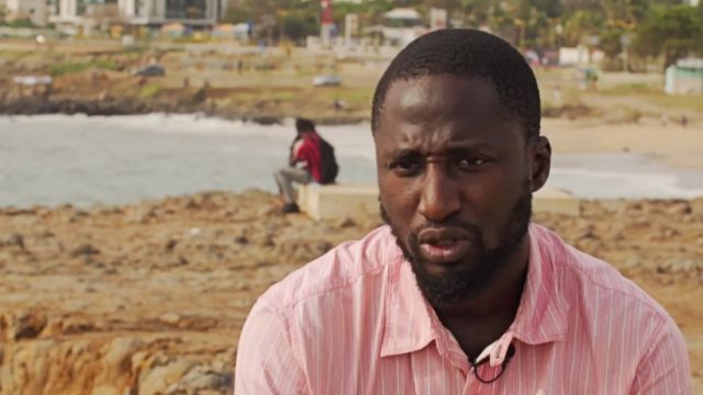
A pesar de tener solo siete médicos por cada 100.000 habitantes, Senegal se ha ganado no pocos elogios por su manejo de la pandemia de coronavirus. Mayeni Jones y Naomi Scherbel-Ball, de la BBC, analizan cómo este país africano logró mantener a raya a la covid-19.
«Cuando llegó el primer caso, estábamos muy ansiosos y yo me enojé porque era un caso importado», cuenta la doctora Khardiata Diallo, quien coordina el centro de tratamiento epidémico del Hospital Fann en la capital, Dakar.
«Nos preocupaba la falta de equipamiento para tratar el coronavirus, había solo 12 camas con suministro limitado de oxígeno para todo el país«.
Pie de foto. Los médicos del Hospital Fann ahora pueden monitorear a los pacientes usando cámaras, como medida para minimizar el contacto.
Eso fue a finales de febrero, cuando un ciudadano francés regresó a Dakar, después de unas vacaciones en un centro de esquí, con fiebre, dolor de garganta y dolor de cabeza.
Fue el primer caso de covid-19 en Senegal y el segundo caso reportado en África subsahariana.
Diallo, que formó parte del equipo que trató el único caso de ébola del país durante el brote que afectó a África occidental en 2014 y tiene experiencia en brotes de cólera en los últimos 15 años, sabía que debían actuar rápido para contener la pandemia.
Tests gratuitos las 24 horas
Sus colegas del prestigioso Instituto Pasteur de Dakar, que en febrero fue uno de los dos laboratorios de África que podían realizar pruebas de coronavirus, capacitaron a personal de decenas de otros países sobre cómo realizar las pruebas.
Pie de foto. Ibrahima Diop fue primero diagnosticado y tratado por malaria cuando contrajo el nuevo coronavirus en abril.
En abril, 43 países del continente africano podían diagnosticar covid-19 de manera efectiva.
Hoy en día, el laboratorio en Dakar funciona las 24 horas y las pruebas se han extendido por todo el país.
Los tests para aquellos que tienen síntomas son gratuitos y los resultados se obtienen en ocho horas.
Si bien ha habido preocupaciones sobre el bajo número de pruebas en todo el continente, el Centro Africano para el Control de Enfermedades está apoyando a los países para aumentar los niveles de testeo y hay esperanzas de que los kits de diagnóstico baratos puedan ayudar.
El Instituto Pasteur ha sido crucial en este esfuerzo, ya que su virólogo jefe, Amadou Sall, se asoció con la firma británica Mologic para desarrollar dos kits de prueba caseros:
Uno para probar si alguien tiene el virus actualmente, similar a las pruebas PCR de laboratorio
El otro para comprobar si alguien ha desarrollado anticuerpos contra el coronavirus de una infección anterior
La fabricación de la prueba de anticuerpos ya comenzó y deberían lanzarse en las próximas semanas, explica Sall.
Funcionará como un test de embarazo, con un costo cercano a US$1 y con resultados en solo 10 minutos.
Mientras, la prueba para determinar si alguien tiene coronavirus se ha retrasado y está siendo validada por la Escuela de Medicina Tropical de Liverpool, pero hay esperanzas de que aún esté disponible antes de fin de año.
Un mayor nivel de pruebas también deberían ayudar a realizar diagnósticos tempranos.
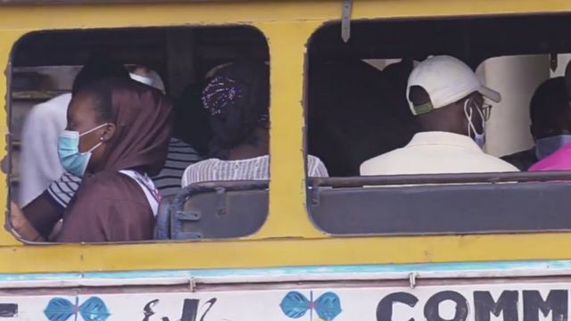
Pie de foto. El uso de mascarillas es obligatorio en Dakar.
Ibrahima Diop, de 29 años y quien trabaja en un call center en Dakar, se enfermó en abril y fue tratado inicialmente por malaria.
Ante la insistencia de su madre, quien trabajaba en un hospital, fue a que le hicieron la prueba y le diagnosticaron coronavirus, junto con 60 de sus colegas. Recibió rápidamente tratamiento y fue dado de alta del hospital en una semana.
Su caso mostró la necesidad de que las personas se realicen pruebas en un país donde los síntomas pueden confundirse fácilmente con la malaria, algo que las autoridades han enfatizado durante sus sesiones informativas televisadas diariamente sobre el coronavirus.
Cantar para combatir el virus
Un índice de respuesta global a la covid-19 de la revista Foreign Policy otorgó a Senegal la puntuación más alta posible por su estrategia de comunicación, a la que se unieron los mejores músicos del país para informar a la gente.
En abril, se juntaron para lanzar Daan Corona, que significa «Derrotar al coronavirus» en wolof, el idioma local.
En la canción, el famoso músico senegalés Youssou Ndour pide a la gente que se quede en casa y se lave las manos.
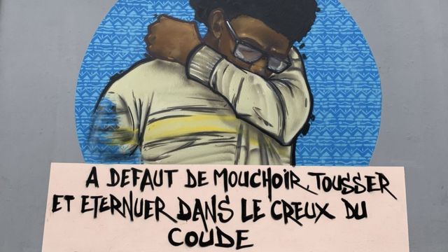
También hay coloridos murales en la universidad más antigua de Senegal que muestra a los estudiantes las técnicas adecuadas para evitar la transmisión del coronavirus.
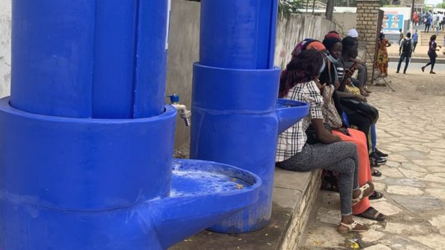
En algunas áreas se instalaron lavabos públicos para que la población pueda lavarse las manos.
En los primeros días de la pandemia, se implementaron otras medidas preventivas, incluida la declaración del estado de emergencia, el cierre total de las escuelas y un toque de queda nocturno.
Los restaurantes, supermercados y bancos se apresuraron a introducir controles de temperatura en sus entradas.
Pie de foto. Murales en Dakar muestran los métodos para evitar la propagación del virus.
Pie de foto. Los lavabos públicos se ven en varias calles de Dakar para que la gente pueda lavarse las manos.
Si bien algunas de esas medidas fueron levantadas, en las calles de Dakar las mascarillas siguen siendo obligatorias, una regla que se introdujo ya en abril.
Hoy en día, las 14 regiones de Senegal están equipadas para tratar a pacientes con coronavirus.
En la sala para los enfermos graves de coronavirus del Hospital Fann de Dakar, Oumar Kane monitorea a su último paciente con coronavirus que depende de un respirador.
El hombre de 58 años ha sido tratado allí durante poco más de una semana, y es diabético.
Para minimizar el contacto, las cámaras de la sala se conectan a una pantalla fuera.
Pie de foto. La popular hermandad musulmana Mouride le pide a la población que use mascarillas.
Pero en marzo, cuando los casos en Senegal comenzaron a aumentar, el doctor Kane recuerda una situación muy diferente.
«El problema era que solo teníamos 10 camas con respiradores y había momentos en que recibíamos llamadas pidiendo una cama pero no podíamos recibir al paciente», recuerda.
«Esa demanda continuó durante unas tres semanas, hasta que se equiparon otros hospitales».
El número de casos diarios registrados ha ido disminuyendo desde mediados de agosto.
Senegal, que tiene una población de 16 millones de personas, solo había registrado hasta esta semana 15.000 casos positivos y poco más de 300 muertes.
Su estrategia para contener el virus se ha adaptado y muchos pacientes con síntomas leves ahora son tratados en casa, con personal médico monitoreando su estado de forma remota desde el hospital y entregando medicamentos.
El desafío de la peregrinación musulmana
Cuando los vuelos internacionales reabrieron en julio, existía la preocupación de que hubiera un aumento en los casos.
Senegal, como muchos otros países africanos, ha pedido a los visitantes que presenten una prueba negativa fechada no más de una semana antes del viaje.
A su llegada, se toma la temperatura de los pasajeros.
FUENTE DE LA IMAGEN,AFP
Pie de foto. En la tumba del fundador de la hermandad Mouride se suelen concentrar grandes concentraciones durante la peregrinación de Grand Magal.
Estas medidas parecen haber funcionado, como muestra el bajo número de casos importados.
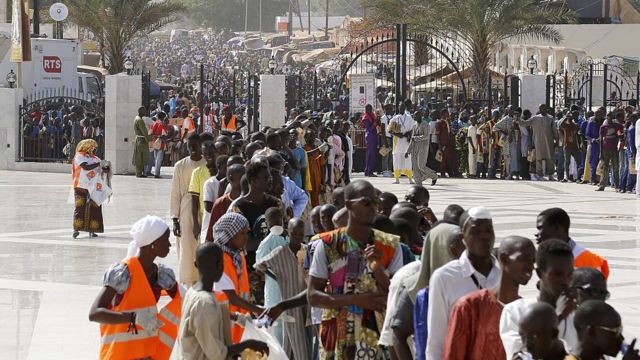
Se espera que esta semana cuatro millones de personas asistan a la fiesta anual más grande del país, el Grand Magal de Touba.
Es una peregrinación histórica a Touba, que se encuentra a 190 km al este de Dakar y es el hogar espiritual de la hermandad musulmana Mouride.
Los peregrinos hacen cola durante horas en las calles de la ciudad para llegar a la Gran Mezquita y al mausoleo del fundador de la hermandad.
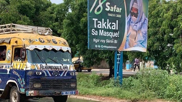
Si bien los carteles alrededor de la capital muestran al líder de la comunidad pidiendo a sus seguidores que usen mascarillas, reunir a un número tan grande de fieles en un solo lugar será una prueba crucial cuando el país busca mantener el progreso logrado.
Conseguir que la vacuna se pueda aplicar a toda la población, incluidos niños y adolescentes, es una de las claves para prevenir rebrotes del virus en centros educativos.
La farmacéutica china Sinovac comenzará el 28 de este mes, dentro de apenas once días, a probar su vacuna contra el coronavirus en adolescentes y niños, después de que las pruebas realizadas en adultos, que se encuentran en la fase final, hayan dado resultados positivos, confirmaron hoy a Efe fuentes de la compañía.
Sinovac anunció el pasado 9 de septiembre que los resultados de los ensayos de su vacuna CoronaVac en las fases 1 y 2 habían mostrado “buena seguridad e inmunogenicidad” en adultos sanos mayores de 60 años al igual que lo hicieron entre las personas de entre 18 y 59 años.
Los niveles de anticuerpos en los mayores de 60 fueron ligeramente inferiores a los que arrojaron las pruebas con población más joven, según la compañía.
Conseguir que la vacuna se pueda aplicar a toda la población, incluidos niños y adolescentes, es una de las claves para prevenir rebrotes del virus en las escuelas y guarderías.
Según un registro del estudio publicado en su página web por la Biblioteca Nacional de Medicina de EE.UU., hasta 552 personas sanas de entre 3 y 17 años recibirán dos dosis de CoronaVac y un placebo, una prueba que combinará las fases 1 y 2 de ensayos clínicos.
Los ensayos comenzarán el 28 de septiembre en la provincia nororiental china de Hebei, que circunda a Pekín.
La vacuna de Sinovac, que en Latinoamérica se produce en cooperación con el instituto brasileño Butantan, con sede en Sao Paulo, se encuentra en la última fase de ensayos en adultos a gran escala en países como Brasil, Indonesia o Turquía.
El gobernador del Estado de Sao Paulo, Joao Doria, aseguró el pasado lunes que pretenden inmunizar con la vacuna china a todos los brasileños y posteriormente a otros países de Latinoamérica.
La Agencia Nacional de Vigilancia Sanitaria (Anvisa) de Brasil ha autorizado pruebas clínicas en 9.000 voluntarios de la vacuna de Sinovac.
La CoronaVac tiene aseguradas 46 millones de dosis en el país sudamericano hasta diciembre y otros 16 millones para el primer trimestre de 2012, según a las autoridades brasileñas.
Cerca del 90 por ciento de los empleados de la farmacéutica china en todo el mundo y sus familias han recibido sus dosis, según la empresa.
Cuatro vacunas chinas se encuentran actualmente en la fase 3 de ensayos clínicos –entre un total de nueve en el mundo–, aunque una de las cinco restantes forma parte de un consorcio formado por la china Fosun Pharma, la alemana Biontech y la estadounidense Pfizer.
Las cuatro totalmente chinas son las de Sinovac, Sinopharm, el Instituto de Productos Biológicos de Wuhan y la de Cansino Biologics, que comenzó a usarse a finales de junio en el Ejército chino.
OtrasVocesenEducacion.org existe gracias al esfuerzo voluntario e independiente de un pequeño grupo de docentes que decidimos soñar con un espacio abierto de intercambio y debate.
¡Ayúdanos a mantener abiertas las puertas de esta aula!


.")


 Users Today : 114
 Total Users : 35495363
 Views Today : 116
 Total views : 3614642